

Numerical weather prediction
Numerical weather prediction method uses mathematical formulation of atmospheric processes to predict the weather. Model is computer program that produces meteorological information about future state of the atmosphere.
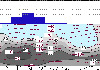
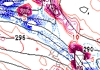
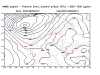
Republic Hydrometeorological Service of Serbia runs two models operationaly. Eta model is running twice a day on ECMWF boundary conditions for 84 hours of forecast. Domain covers Europe, East Atlantic and Northern part of Africa
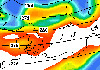
WRF-NMM model, created in NCEP (National Center for Enviromental Prediction) Washington is next-generation mesoscale model with sophisticated physics and new numerical approach. Current horizontal resolution is about 4km, number of numerical points is 220x290. Model is running twice a day on ECMWF boundary conditions for 72 hours ahead. Domain covers Balkan and Adriatic Sea.
Republic Hydrometeorological Service of Serbia runs two models operationaly. Eta model is running twice a day on ECMWF boundary conditions for 84 hours of forecast. Domain covers Europe, East Atlantic and Northern part of Africa
WRF-NMM model, created in NCEP (National Center for Enviromental Prediction) Washington is next-generation mesoscale model with sophisticated physics and new numerical approach. Current horizontal resolution is about 4km, number of numerical points is 220x290. Model is running twice a day on ECMWF boundary conditions for 72 hours ahead. Domain covers Balkan and Adriatic Sea.
Meteogram shows time variation of meteorological parameters, such as wind on standard pressure levels, temperature on 2m,
relative humidity, precipitation...
Forecasting SKEW-T diagram shows vertical structure of the atmosphere for chosen point and forecast time.

NMMB - Nonhydrostatic Muli-scale Model developed in NCEP by Z. Janjić, in operational use
in RHMSS since January 2012.
|
|
|
 Page print Page print |
| © 2026 Copyright RHMS of Serbia |