


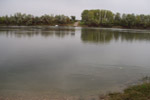
Map presentation of hydrological stations network of surface water and underground water of first (freatic) groundwater and reporting hydrological stations; basic data of hydrological stations; actual data of surface water status; forecasts for water stage and ice events on rivers; information about hydrological data base, hydrological annual books, expert opinion in the procedure of acquiring water managament conditions.
Presentation of organizational scheme for managament of hydrological stations network and basin of major rivers, distribution of hydrological stations for monitoring of regime characteristics of surface and ground water. Basic technical data and programs which are carried out on hydrological stations.
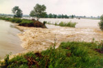
Map presentation of reporting hydrological stations network, actual daily and yearly data, forecast from 2 to 4 days, characteristic values of water stage, river flow and water temperature for reporting stations on the Dunav, Tisa, Sava and Morava. Information about activity of the Department for Water Forecast.
Monitoring of surface water regime on the territory of Serbia; analysis and processing elements of the water balance; processing and control of hydrological parameters;
keeping records and hydrological database of surface and ground water; preparation and issuance of hydrological data; preparation of hydrological analysis, surveys and studies;
production of hydrological basis for individual basins and the whole territory of Serbia and display information in the form of generalized maps, regional dependence and the like;
study of the spatial and temporal distribution of hydrological variables with the aim of studying water resources; production, maintenance and updating of cadastre physical-geographical and hydrological characteristics of catchments;
issuing expert opinions; issuing meteorological conditions.
|
|
|
 Page print Page print |
| © 2026 Copyright RHMS of Serbia |