| Station |
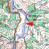
GORNJA GOREVNICA |
| River |
ČEMERNICA |
| Basin |
ZAPADNA MORAVA |
| Foundation year |
1965 |
| KOTA “0” (m n.J.m.) |
300 |
| Distance from the river mouth (km) |
21.500 |
| Basin area (km2) |
143 |
| |
|
| Elements of measurement and observation |
| |
|
| Mode of water stage recording: |
| staff guage from (year): |
1966 |
| limnigraph from (year): |
1994 |
| digital registration from (year): |
- |
| |
|
| river flow measurement from (year): |
1965 |
| water temperature from (year): |
1998 |
| transport of suspended sediment from (year): |
- |
| ice events from (year): |
2001 |
| water quality monitoring from (year): |
- |
| mode of reporting: |
|


 Page print