

Reporting surface water station: MILOČAJ
Choose name of station for more information.| Station: | MILOČAJ | ||
|---|---|---|---|
| River: | ZAPADNA MORAVA | ||
| Basin: | VELIKA MORAVA | ||
| Foundation year: | 1986 | ||
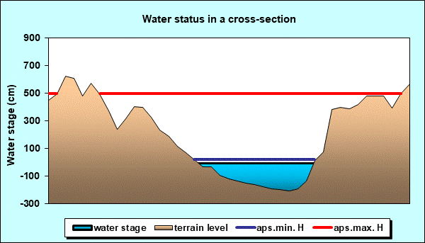
| KOTA "0" (m n.J.m.): | 194.27 | ||
| Distance from the river mouth (km): | 103.9 | ||
| Basin area (km2): | 4658 | ||
| Date: TUESDAY, 10.03.2026. | |||
| Water stage (cm) |
Change of water stage (cm) |
River flow (m3/s) |
Water temperature (оC) |
| * |
|||
| Tendency | Ice events | First flood alert (cm) |
Second flood alert (cm) |
 |
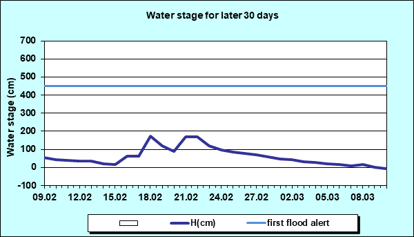
- | 450 | 550 |
| Water stage forecast | Weekly range | ||||
|---|---|---|---|---|---|
| Day: | WEDNESDAY ÷ TUESDAY | ||||
| Date: | 04.03. ÷ 10.03. | ||||
| Water stage (cm): | 10 ÷ 100 | ||||
Diagrams


|
|
|
 Page print Page print |
| © 2026 Copyright RHMS of Serbia |