

Reporting surface water station: APATIN
Choose name of station for more information.| Station: | APATIN | ||
|---|---|---|---|
| River: | DUNAV | ||
| Basin: | CRNO MORE | ||
| Foundation year: | 1876 | ||
| KOTA "0" (m n.J.m.): | 78.84 | ||
| Distance from the river mouth (km): | 1401.900 | ||
| Basin area (km2): | 211139 | ||
| Date: SUNDAY, 17.05.2026. | |||
| Water stage (cm) |
Change of water stage (cm) |
River flow (m3/s) |
Water temperature (оC) |
| * |
|||
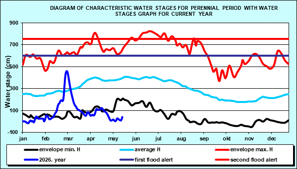
| Tendency | Ice events | First flood alert (cm) |
Second flood alert (cm) |
 |
- | 600 | 750 |
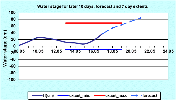
| Water stage forecast | Weekly range | ||||
|---|---|---|---|---|---|
| Day: | MONDAY | TUESDAY | WEDNESDAY | THURSDAY | WEDNESDAY ÷ TUESDAY |
| Date: | 18.05. | 19.05. | 20.05. | 21.05. | 13.05. ÷ 19.05. |
| Water stage (cm): | 55 | 65 | 75 | 85 | -10 ÷ 70 |
Diagrams


|
|
|
 Page print Page print |
| © 2026 Copyright RHMS of Serbia |