| Station |
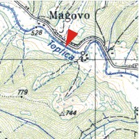
MAGOVO |
| River |
TOPLICA |
| Basin |
JUŽNA MORAVA |
| Foundation year |
1951 |
| KOTA “0” (m n.J.m.) |
523.15 |
| Distance from the river mouth (km) |
100.000 |
| Basin area (km2) |
180 |
| |
|
| Elements of measurement and observation |
| |
|
| Mode of water stage recording: |
| staff guage from (year): |
1951 |
| limnigraph from (year): |
1978 |
| digital registration from (year): |
2006 |
| |
|
| river flow measurement from (year): |
1958 |
| water temperature from (year): |
- |
| transport of suspended sediment from (year): |
1973 |
| ice events from (year): |
1986 |
| water quality monitoring from (year): |
- |
| mode of reporting: |
|


 Page print